Bikeability Models as a Tool for Cycling Network Planning

What makes a street or a city bicycle-friendly – and who decides? Bikeability assessment models provide comparable, data-driven answers to these questions. A look behind the scenes at the Mobility Lab of the Department of Geoinformatics (Z_GIS) at the University of Salzburg, a member of Cycle Competence Austria, shows how geospatial methods support cycling planning, policymaking and practice around the world.
Requirements for Bikeability Assessment
There is broad agreement that increasing cycling rates requires more than isolated infrastructure projects. Measures implemented during road works or new developments alone are not enough. What matters is the creation of coherent cycling networks: regional networks that connect settlements, as well as intuitive, safe and attractive networks within towns and cities.
The same applies to planning concepts such as Superblocks and the 15-minute city. Rather than focusing on individual streets, they require a system-wide approach that prioritises the quality of the entire network.
What is a Bikeability Model?
A bikeability model uses objective data to assess how suitable streets, paths or entire networks are for cycling. Different characteristics of the infrastructure and its surroundings are combined into indicators that support comparison, analysis and evidence-based planning.
Both the quality of individual street segments and that of entire cycling networks can be described using bikeability assessment models. The term bikeability has become internationally established for this type of evaluation. These models typically incorporate measurable indicators such as street characteristics, network continuity, accessibility of destinations (Points of Interest, POIs) and environmental factors such as green space or air quality. The resulting indicators enable analyses, simulations and comparisons between cities and regions.
Different User Groups Have Different Requirements
Unlike subjective assessments, bikeability models are based on structural data. However, they inevitably reflect assumptions about their intended users and purpose. For example, a steep, unpaved road may be unsuitable for everyday cycling but ideal for mountain biking. Likewise, experienced commuters may prioritise direct routes, whereas a school class values safe crossings, attractive destinations along the route and a pleasant environment. These examples illustrate that bikeability models are most useful when they reflect the needs of different user groups.
Geoinformatics Meets Cycling Planning
Bikeability is closely linked to geoinformatics. In Geographic Information Systems (GIS), streets are represented as digital networks whose geometry, topology and attributes can be analysed. In Austria, the national Graph Integration Platform (GIP) provides an important public data source, while the globally available OpenStreetMap has become the leading open-data alternative.
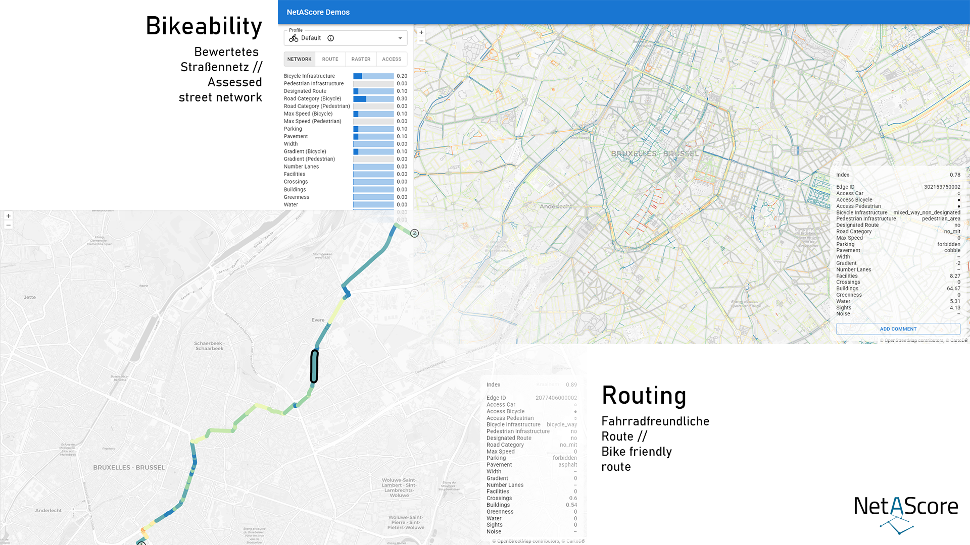
NetAScore: Open-Source Software Developed by the Mobility Lab
For more than 15 years, the Mobility Lab at the University of Salzburg has been researching methods to assess the bicycle-friendliness of transport infrastructure. One of its key developments is NetAScore, an open-source software framework that helps answer practical planning questions such as:
- How bicycle-friendly is a street network as a whole?
- Which routes offer the highest levels of safety and comfort?
- How well are key destinations accessible by bicycle?
- Where are the missing links in the cycling network?
- What network-wide effects can be expected from new cycling infrastructure?
Research at the Mobility Lab has covered the full workflow, from data preparation and model calibration to integration into bicycle routing services. Today, its work focuses primarily on the system-wide analysis and evaluation of cycling networks.
From Salzburg to Practice – Worldwide
As an open-source tool, NetAScore is used in planning projects around the world, from Austria to Europe and Asia. In Austria, it has supported projects including the study “Safe Cycling Networks, Safe Walking Networks and Bike & Ride Accessibility [link to german website]” and the development of the strategic cycling network VISION.
The Mobility Lab is currently extending the application of NetAScore through two European research projects:
- CITWIN applies bikeability assessment within digital twins for urban mobility. The project analyses accessibility to everyday destinations for active mobility in Eskilstuna (Sweden), Aarhus (Denmark) and Brussels (Belgium). link to project website
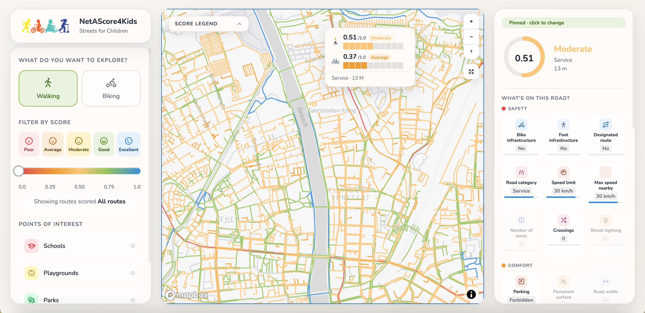
- i-mobyl focuses on children and young people and is developing NetAScore4Kids, a bikeability assessment specifically tailored to their mobility needs. link to project website
The adaptability and transferability of NetAScore highlight one of the key strengths of open-source systems. Existing components can be reused and adapted to new applications without the need to develop entirely new frameworks.
Benefits for Planning and Society
Bikeability models provide a robust evidence base for targeted cycling planning. They help prioritise investments, compare planning options and measure progress over time. Their value, however, extends beyond technical analysis. Better cycling infrastructure contributes to more sustainable mobility, improved public health and a higher quality of urban life. By combining scientific research, open data and practical application, tools such as NetAScore have become valuable instruments for supporting the transition towards more sustainable transport systems.
Figures: Mobility Lab, Department of Geoinformatics (Z_GIS), University of Salzburg
Further link
Mobility Lab https://mobilitylab.zgis.at/
Cycling Competence Members in this article:
More articles with this member:
[crp]
Share this article:
Bikeability Models as a Tool for Cycling Network Planning
Share this article:
What makes a street or a city bicycle-friendly – and who decides? Bikeability assessment models provide comparable, data-driven answers to these questions. A look behind the scenes at the Mobility Lab of the Department of Geoinformatics (Z_GIS) at the University of Salzburg, a member of Cycle Competence Austria, shows how geospatial methods support cycling planning, policymaking and practice around the world.
Requirements for Bikeability Assessment
There is broad agreement that increasing cycling rates requires more than isolated infrastructure projects. Measures implemented during road works or new developments alone are not enough. What matters is the creation of coherent cycling networks: regional networks that connect settlements, as well as intuitive, safe and attractive networks within towns and cities.
The same applies to planning concepts such as Superblocks and the 15-minute city. Rather than focusing on individual streets, they require a system-wide approach that prioritises the quality of the entire network.
What is a Bikeability Model?
A bikeability model uses objective data to assess how suitable streets, paths or entire networks are for cycling. Different characteristics of the infrastructure and its surroundings are combined into indicators that support comparison, analysis and evidence-based planning.
Both the quality of individual street segments and that of entire cycling networks can be described using bikeability assessment models. The term bikeability has become internationally established for this type of evaluation. These models typically incorporate measurable indicators such as street characteristics, network continuity, accessibility of destinations (Points of Interest, POIs) and environmental factors such as green space or air quality. The resulting indicators enable analyses, simulations and comparisons between cities and regions.
Different User Groups Have Different Requirements
Unlike subjective assessments, bikeability models are based on structural data. However, they inevitably reflect assumptions about their intended users and purpose. For example, a steep, unpaved road may be unsuitable for everyday cycling but ideal for mountain biking. Likewise, experienced commuters may prioritise direct routes, whereas a school class values safe crossings, attractive destinations along the route and a pleasant environment. These examples illustrate that bikeability models are most useful when they reflect the needs of different user groups.
Geoinformatics Meets Cycling Planning
Bikeability is closely linked to geoinformatics. In Geographic Information Systems (GIS), streets are represented as digital networks whose geometry, topology and attributes can be analysed. In Austria, the national Graph Integration Platform (GIP) provides an important public data source, while the globally available OpenStreetMap has become the leading open-data alternative.
NetAScore: Open-Source Software Developed by the Mobility Lab
For more than 15 years, the Mobility Lab at the University of Salzburg has been researching methods to assess the bicycle-friendliness of transport infrastructure. One of its key developments is NetAScore, an open-source software framework that helps answer practical planning questions such as:
- How bicycle-friendly is a street network as a whole?
- Which routes offer the highest levels of safety and comfort?
- How well are key destinations accessible by bicycle?
- Where are the missing links in the cycling network?
- What network-wide effects can be expected from new cycling infrastructure?
Research at the Mobility Lab has covered the full workflow, from data preparation and model calibration to integration into bicycle routing services. Today, its work focuses primarily on the system-wide analysis and evaluation of cycling networks.
From Salzburg to Practice – Worldwide
As an open-source tool, NetAScore is used in planning projects around the world, from Austria to Europe and Asia. In Austria, it has supported projects including the study “Safe Cycling Networks, Safe Walking Networks and Bike & Ride Accessibility [link to german website]” and the development of the strategic cycling network VISION.
The Mobility Lab is currently extending the application of NetAScore through two European research projects:
- CITWIN applies bikeability assessment within digital twins for urban mobility. The project analyses accessibility to everyday destinations for active mobility in Eskilstuna (Sweden), Aarhus (Denmark) and Brussels (Belgium). link to project website
- i-mobyl focuses on children and young people and is developing NetAScore4Kids, a bikeability assessment specifically tailored to their mobility needs. link to project website
The adaptability and transferability of NetAScore highlight one of the key strengths of open-source systems. Existing components can be reused and adapted to new applications without the need to develop entirely new frameworks.
Benefits for Planning and Society
Bikeability models provide a robust evidence base for targeted cycling planning. They help prioritise investments, compare planning options and measure progress over time. Their value, however, extends beyond technical analysis. Better cycling infrastructure contributes to more sustainable mobility, improved public health and a higher quality of urban life. By combining scientific research, open data and practical application, tools such as NetAScore have become valuable instruments for supporting the transition towards more sustainable transport systems.
Figures: Mobility Lab, Department of Geoinformatics (Z_GIS), University of Salzburg
Further link
Mobility Lab https://mobilitylab.zgis.at/
Cycling Competence Members in this article:
More articles with this member:
[crp]